
What the National Weather Service Reported
At 5:23 PM CDT on June 11, 2025, the National Weather Service office in Springfield, Missouri issued a Severe Thunderstorm Warning (event code: SVRSGF) for northern St. Clair County in west central Missouri. The warning remained in effect until 6:15 PM CDT.
According to the NWS, a severe thunderstorm was confirmed by radar at 5:22 PM CDT, located over Montrose — approximately 13 miles southwest of Clinton — and tracking east at 30 mph. The two primary hazards identified were:
- Wind gusts up to 60 mph, capable of direct structural damage to roofs, siding, and trees
- Hail up to 1.25 inches in diameter (half-dollar size), large enough to cause significant damage to roofing materials, gutters, and vehicles
The NWS explicitly noted that hail damage to vehicles was expected, and that wind damage to roofs, siding, and trees was anticipated along the storm's path. Even if your home did not sustain visible damage from the ground, storms of this intensity routinely cause granule loss, bruising, and micro-fractures in roofing materials that are only identifiable through a professional inspection.
Immediate Safety Steps for Homeowners
If you were in the path of this storm, your first priority is safety — not damage assessment. Before you begin any inspection of your property, confirm that the storm has fully passed and no additional warnings are active for your area. The NWS Storm Prediction Center and local NWS Springfield forecasts are your most reliable real-time sources.
Steps to take in the first few hours after the storm
- Stay inside until the warning period has ended. The warning extended to 6:15 PM CDT. Do not go outside during active lightning or high-wind conditions.
- Check for downed power lines around your property. Do not touch or approach downed lines under any circumstances. Call your utility provider and 911 immediately if you see one.
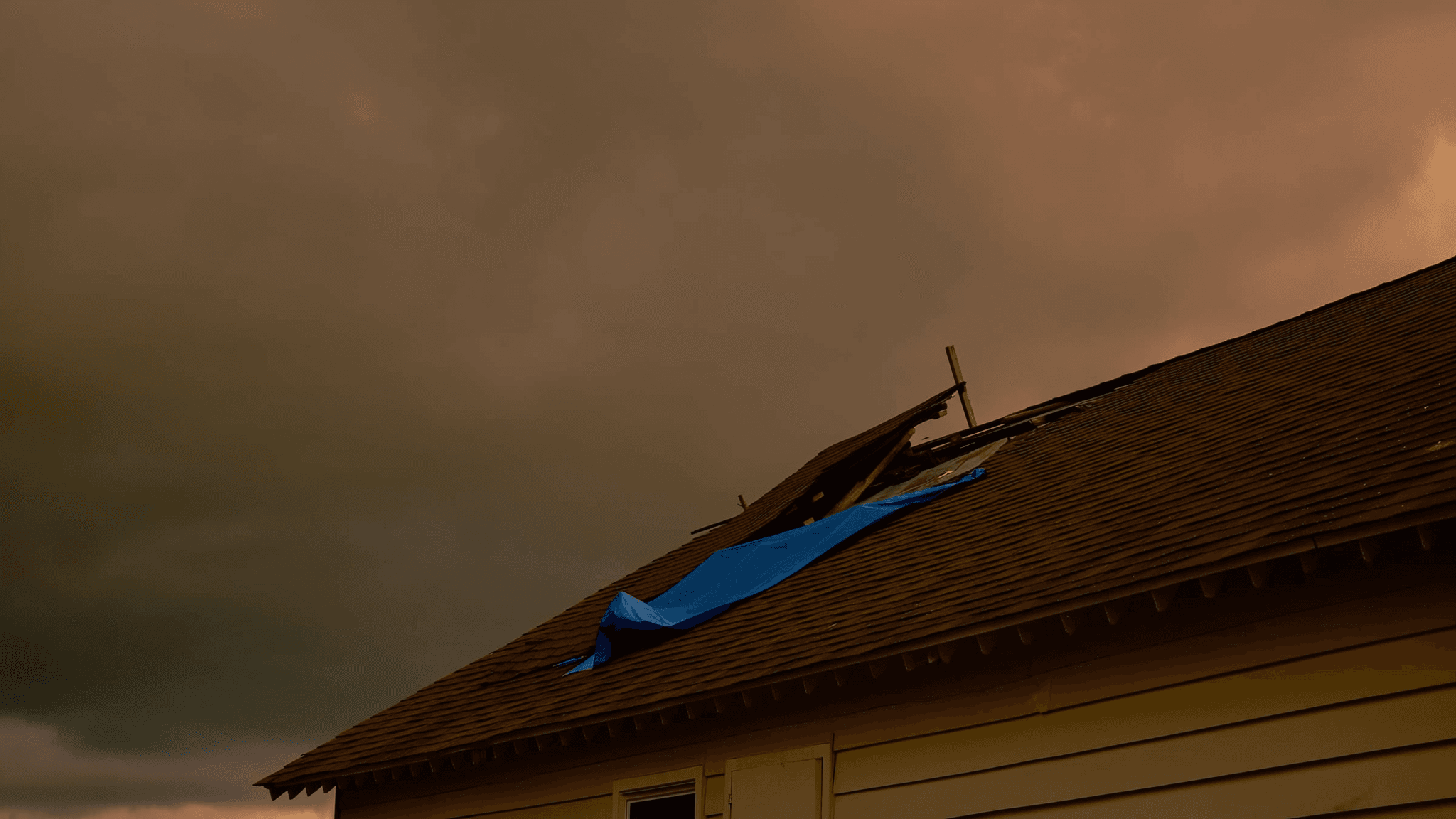
- Look for visible structural damage from a safe vantage point on the ground. Missing shingles, displaced ridge caps, or debris on the roof are signs that professional inspection is warranted.
- Document everything before touching or cleaning anything. Photograph all visible damage to your roof, gutters, siding, windows, and yard. Timestamps are important for insurance purposes.
- Check your attic for signs of water intrusion. Water stains, dripping, or wet insulation after a storm often indicate a roof breach that is not visible from the exterior.
- Do not attempt to walk your own roof. Wet or damaged roofing surfaces are a fall hazard, and untrained foot traffic can extend existing damage.
What Storm Damage to Look For After This Event
A combination of 60 mph winds and 1.25-inch hail creates a specific and well-documented damage profile. Understanding what to look for helps you communicate clearly with your insurance adjuster and roofing contractor.
Hail damage indicators
Half-dollar-size hail at this diameter is above the threshold at which most asphalt shingle manufacturers consider impact damage to be covered under standard warranties. Key signs include:
- Granule loss in circular or random patterns on asphalt shingles — granules protect the underlying mat from UV and water degradation
- Bruising or soft spots on shingles where hail impact has compromised the mat beneath the surface, detectable by touch during a professional inspection
- Dents on metal components including gutters, downspouts, flashing, vent caps, and ridge vents
- Cracked or chipped slate or tile if applicable to your roofing system
- Damaged soffit and fascia along the roofline perimeter
Wind damage indicators
Wind gusts at 60 mph fall into the range where direct structural uplift becomes a real concern for standard residential roofing systems, particularly on older installations or homes with compromised sealants.
- Missing, lifted, or creased shingles — particularly at ridges, edges, and corners where wind leverage is greatest
- Exposed underlayment or decking where shingle blow-off has occurred
- Damaged or displaced ridge caps
- Debris impact punctures from branches or projectiles
- Siding displacement or cracking along wall planes exposed to the storm's direction of travel
- Gutter separation from fascia due to wind load or debris impact
It is also worth noting that tree damage in your yard is a secondary indicator. If mature trees lost limbs or were uprooted near your home, the same wind force was acting on your roof simultaneously. Learn more about Vulcan Construction's storm damage services and what a post-storm inspection covers.
How to Handle Your Insurance Claim
Filing a storm damage claim correctly from the beginning protects your settlement amount and prevents delays. Insurance companies operate on documentation, timelines, and policy language — and storm claims in particular are often underpaid when homeowners are not prepared.
Steps to take before your adjuster arrives
- Contact your insurance carrier promptly. Most policies require you to report storm damage within a defined window. Do not wait for a contractor before calling your insurer.
- Preserve all photographic evidence. Use a camera or smartphone with location and timestamp data enabled. Photograph every affected surface from multiple angles.
- Keep records of all temporary repairs. If you need to apply a tarp or board up a window to prevent further damage, document the cost. Most policies reimburse reasonable emergency mitigation expenses.
- Do not authorize permanent repairs before your adjuster has inspected. Premature repairs can complicate or void a claim.
- Request a copy of your policy's declarations page so you understand your deductible, coverage limits, and whether you carry Actual Cash Value (ACV) or Replacement Cost Value (RCV) coverage.
Getting a professional roof inspection before the adjuster visit
One of the most effective steps a homeowner can take is scheduling an independent roofing inspection before the insurance adjuster arrives. A documented inspection report from a licensed contractor gives you an objective, professional baseline that you can present alongside your claim. It also ensures that damage the adjuster may overlook — particularly hail bruising, which requires close inspection — is on the record.
Vulcan Construction provides post-storm inspections and works directly with insurance adjusters throughout the St. Louis market. Request a free estimate to get an inspection scheduled.
If you are preparing to file a claim or are already in the claims process, our insurance claim packet is designed to help homeowners organize documentation, understand their rights, and communicate effectively with their carrier. Download Vulcan's insurance claim packet here.
What Repairs May Be Needed and What to Expect
Depending on the age of your roof and the intensity of storm exposure in your specific location, damage from this event may range from localized shingle replacement to a full roof system replacement. Homes with roofs that are 10 years or older are more likely to sustain threshold damage from a storm at this hail and wind level.
It is worth understanding the cost range for roofing work in the St. Louis area before you receive contractor quotes or an insurance estimate. Knowing the market baseline helps you evaluate whether an insurance settlement is adequate. See current roofing costs in the St. Louis, MO area.
Vulcan Construction operates as a roofing-first construction company, meaning every project begins with a thorough assessment of the roof system before any other scope is determined. Siding, gutters, and related components are evaluated in the context of how they interact with the roof — not as standalone line items. This integrated approach matters particularly for storm claims, where multiple systems are often affected simultaneously.
A Note on Future Roof Planning
If a storm like this has prompted you to think about what comes next for your home — whether that is a roof replacement, an upgrade in materials, or longer-term planning for your property — Vulcan Construction is available to discuss your options in detail. For homeowners interested in solar readiness, we approach that conversation from a roof-first planning perspective, ensuring your roof system is designed and installed with future energy considerations in mind. Specific solar product offerings and pricing are in development as we finalize supplier partnerships, and we will share full details as they become available.
The most important step after any storm event is a qualified inspection. Visit our storm damage services page to understand our inspection and repair process, or schedule your free estimate today.